
By Ashly Winchester

Difficulty: Hard
Type: Mostly Off-trail, Scramble
Round Trip Distance: 9.5 miles
Elevation Gain: ~3,400 feet
Cell service: Spotty
Best Time of Year: Winter, Spring, Fall
Permits: No
Perk: the trailhead is not within the Red Rock Canyon scenic loop drive, so it can be accessed at all times, even if the drive is closed.

The noise echoed off the canyon walls and I almost tripped over a rock as my gaze shot upwards. Was… was that a bleat? My eyes narrowed and I squinted at the sheer red rock that surrounded me. The sound peeled across the canyon again. Then I saw it: a Bighorn Sheep gazed over a ledge at me. It screamed again as it started picking its way along the precarious ledge.
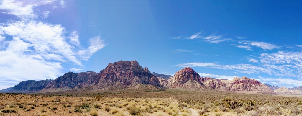
Red Rock National Conservation Area is a popular rock climbing and hiking destination just outside of Las Vegas, Nevada. Being near a large city, the trails are frequently crowded, but it doesn’t take much to get away from the masses… if you’re feeling adventurous.
Overview
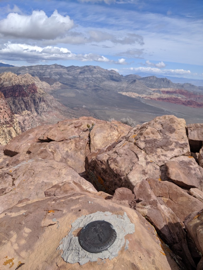
Mount Wilson is the tallest peak in the park at 7,070 feet. This peak commands your attention and garners the adoration of photographers. It rises straight sharply out of the desert floor; the red, orange and tan stripes of Wilson’s face create a stark contrast to the blue desert sky. It can be an intimidating objective for the average day hiker.
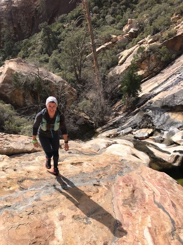
One of my favorite hikes to do in the park is the “hike” to the summit of Mount Wilson. I say “hike” in quotation marks because it is so much more than just a walk in the park; it’s a route-finding, boulder-hopping, scrambly adventure.

This “hike” is full of adventure, unbeatable views, wildlife viewing, and cool plants, all in a full-body workout. What more could you want?
Sound like your cup of tea? Good. Keep reading.
The Beta
Even though the mileage itself is not that extreme, prepare yourself for a long day. Take a backpack with plenty of water and snacks, especially during the warmer times of the year (it is a desert after all), and start early in order to give yourself plenty of time and to do most of the uphill when it’s cooler.

I highly recommend wearing pants and a lightweight, long-sleeved shirt because you may find yourself bush-whacking, and being a desert, some of those plants are pretty spiky and can cause injury. So protect yo’self. Take an extra layer too – depending on the time of year, it can be windy and cool at the summit.
You’ll be walking up slabby slick-rock and making some potentially heady, bouldery moves through the canyon, so wear comfortable, closed-toed shoes with good grip. Climbing approach shoes are perfect for something like this, but trail running shoes and hiking shoes will also work well. I wore a pair of Hoka trail running shoes and they did surprisingly well.
One more thing: TICKS. There are ticks. And they are voracious little disease-toting bastards. So use a tick repellent, or, at the very least, check yourself and your hiking partners thoroughly afterward.

The Route
Most of the route is off-trail, but with the right beta, it’s fairly simple to find your way.

Start at the First Creek Canyon trailhead just off of SR-159 and head straight towards the canyon. The first ~1.5 miles of trail is relatively flat and easy to follow, then it starts to divide and come back together and just generally wander all over the place. Try to stick close to the creek bed and keep heading up the canyon. At this point, you can even just drop into the creek bed and start your bouldery adventure, but the trail does continue for about 0.7 more miles.
By mile 2.2 you should be following the bouldery creek bed. This is where the fun really begins. You will encounter big rocks to scramble up and slabby slickrock waterfalls. There are cairns here and there that let you know you are going in the correct general direction, but don’t rely on them exclusively because they may lead you astray. (For example: DO NOT follow the cairns up the boulder field on the right side of the canyon around mile 3.5). Your best course of action is to stick to the creek bed, or as close to it as possible, and keep going upstream.

There are two main forks in the canyon, always keep right. The canyon starts to phase out as you climb higher, and eventually you will end up exiting onto a lightly used (but fairly obvious) path. Follow this path and the cairns through the limestone scree and you’ll gain the ridge and be back on the sandstone slickrock. Now you can trust the cairns to lead you in the right direction. I did, and I didn’t have any problems finding the way at this point.
You’re going to encounter two false summits, but don’t give up! You’re almost there! You’ll follow a small gully, taking a left (and continuing to follow the cairns) to the second false summit. Keep following the cairns and the ridgeline.

The trail will drop to the left just after a group of trees, then it will climb sharply up to the actual summit. The final summit block is a very short 3rd class scramble. Some people may find it a little scary due to exposure, but it is relatively easy and there is more than one way to find your way up.
Once you’re on the summit, make sure to take in the views around you and have a look down the 3,000 foot drop on the East side. Don’t forget to sign the summit register!


When you’re ready to leave, just go back the way you came.


Beautiful hike – Thanks!
LikeLiked by 1 person
My pleasure! It’s one of my favorites!
LikeLike